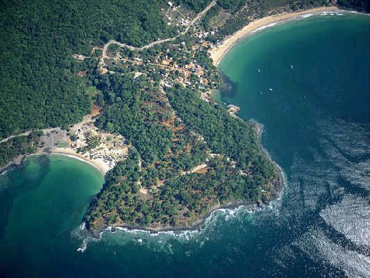
 Map of Chacala
The little beach is Chacalilla and the big beach is Playa Chacala.
The wide line across the top is the paved road.
You approach Chacala from the middle of the top of the photo.
At the north end of Chacala is a smaller beach called Chacalalli. The smaller beach and a large section of land between the two beaches was appropriated by a former Govenor of the state of Nayarit (who went to prison for other deeds), and eventually ended up in the hands of the current developers.
Now the history of Chacalilla has faded into the past, at least for the new landowners in what is now called Marina Chacala, and high-end development. The entrance to the walled, fenced, and gated "community" (to use the term loosely) is at the north end of the paved road to the Marina (also built by the Govenor during his term of office). Large construction vehicles, truckloads of workers, and the residents entering and leaving the Marina (not a marina, there is no marina) honk their horns all day and most of the night, in order to get the "security" guards to let them in.
All beaches in Mexico are public property, and open. But the Marina owners, like owners of other rich people developments have blocked public access completely, except from the ocean side. So local people now come to Chacalilla beach by boat. Works for me.
Okay, next, at the north end of Chacala beach is the muelle. Or little harbor, where the local fishing and tourist boats tie up to a large cement dock that is also used to load and unload large shrimp boats that show up occasionally. The Fishing/Tourist coop has a building here. There is a little sandy beach here, with no waves, and lots of families with little kids, and local folks, swim there.
Then then is a Malecon, a wide pedestrian, dirt path that goes around a small headland to the larger part of Chacala beach. Casa Tortuga, Isreal and Chata's Mirador rentals and home are here, as is Casa Azul, a new gringo mini-house, and four vacation homes owned by people from Guadalajara or elsewhere in Mexico.
Once you are on the main beach, you will see Alvaro's ( expect on the petroglyph's and Huitchol tours) house. Then Mingo's (former) restaurant, and open space where fishermen load and unload their boats to repair and paint them. Then there are a string of restaurants about a third of the way down the beach.
Then there is the coconut grove area, claimed by El Delphin's, where people camp (RV's block the area off in January and February), a couple of more restaurants, and about six small, jerry-built homes. Most of these places offer camping spaces and toilets/showers for campers.
Then down at the south end of the Chacala beach is, first Majahua's shady beach club area, then Mar de Jade (a hotel and retreat center/spa) and then, about 20 feet up from the beach, and tucked into the jungle, the small Majahua resort, spa and restaurant.
My version.
No comments:
Post a Comment